Choosing between the West End and Yaletown is deciding between two ways of life embedded in their very streets.
- The West End’s urban design prioritizes a tranquil, human-scale residential experience with deep roots in nature and community.
- Yaletown’s repurposed industrial core offers a polished, high-energy, commerce-centric vibe defined by its “see-and-be-seen” atmosphere.
Recommendation: For a quiet, nature-adjacent stay where the beach and park feel like your backyard, choose the West End. For a vibrant, stylish urban experience with endless dining and social options at your doorstep, choose Yaletown.
As a relocation specialist in Vancouver, the question I hear most often from visitors isn’t just “where should I stay?” but “where will I *feel* most at home?” When it comes to walkability, two names always surface: the West End and Yaletown. On the surface, the choice seems simple: old versus new, quiet versus bustling. But this barely scratches the surface. The real difference lies in their architectural DNA and the resulting “pedestrian texture”—the feeling you get from the width of the sidewalks, the height of the buildings, and the purpose for which the streets were originally built.
Most guides will give you a list of restaurants and shops. They’ll tell you the West End is next to Stanley Park and Yaletown is on the False Creek seawall. While true, this doesn’t help you choose your vibe. What if the key wasn’t just *what* is in a neighbourhood, but *how* its design makes you feel as you walk through it? Is your ideal afternoon a stroll down a quiet, tree-canopied street towards the ocean, or a confident stride along a sleek, elevated patio scene buzzing with energy? This is the real choice you’re making.
This guide goes deeper. We’ll dissect the core personalities of the West End and Yaletown by looking at their urban planning. To give you a complete picture, we’ll also compare their unique walking experiences to other iconic Vancouver zones—from the artistic alleys of Main Street to the wellness corridor of Kitsilano and the historic cobblestones of Gastown. By understanding these different “vibe zones,” you won’t just find a place to stay; you’ll find the Vancouver that speaks directly to you.
To help you navigate this exploration of Vancouver’s most walkable areas, here is a breakdown of what we will cover. Each section tackles a specific question that reveals the true character of a neighbourhood, allowing you to find the perfect fit for your visit.
Summary: West End or Yaletown: Which Walkable Neighborhood Fits Your Vibe?
- Traffic Calming: Why Are There So Many Roundabouts in the West End?
- The Main Street Mural Walk: How to Find the Hidden Alleyway Art?
- Pender Street: How to Appreciate the Heritage Buildings While Staying Safe?
- West 4th Avenue: Which 5 Blocks Have the Best Athleisure Shops?
- Can You Walk the Entire False Creek Seawall in One Afternoon?
- Yaletown’s Loading Docks: Why Are the Patios Raised Above Street Level?
- The West End Maze: Where to Park for the Beach on a Sunday?
- How to Enjoy Gastown’s Charm While Avoiding Tourist Traps and Gritty Streets?
Traffic Calming: Why Are There So Many Roundabouts in the West End?
The first thing you’ll notice when walking or driving through the West End is the sheer number of roundabouts and traffic circles. These aren’t an accident; they are the most visible evidence of the neighbourhood’s core philosophy: this is a place for people, not for cars. Unlike the grid-like efficiency of downtown, the West End’s design is intentionally disruptive to vehicle flow. This is a deliberate strategy of traffic calming, designed to discourage shortcutting and slow down local traffic to a crawl, making the streets safer and more pleasant for pedestrians and cyclists.
According to the City of Vancouver’s official planning documents, the West End Community Plan explicitly prioritizes pedestrians and green space over vehicle throughput. Those small, often beautifully landscaped roundabouts are more than just traffic devices; they are mini-parks, pedestrian refuges, and a constant reminder that you are in a residential sanctuary. This “human-scale” urban planning preserves the historic character of the area, protecting its charming early 20th-century apartment buildings from the noise and speed of a modern city.
For a visitor, this translates into a uniquely tranquil walking experience. You can stroll down streets lined with mature trees, feeling a sense of safety and separation from the urban rush just a few blocks away. The pedestrian texture is soft, green, and community-oriented. It’s a neighbourhood that invites you to meander, not just to get from point A to B. This design is the fundamental reason the West End feels like a peaceful residential escape, despite its incredibly central location.
The Main Street Mural Walk: How to Find the Hidden Alleyway Art?
While the West End’s character is defined by nature and Yaletown’s by commerce, other Vancouver neighbourhoods offer a different kind of walkable discovery: art. The Main Street corridor, particularly through the Mount Pleasant area, is a vibrant outdoor gallery. The annual Vancouver Mural Festival has transformed the area, turning bland building walls and forgotten alleyways into a sprawling canvas for world-class street art. For the visitor who thrives on creative energy, this offers a completely different pedestrian texture—one of surprise, colour, and urban grit.
Finding the art is an adventure in itself. While many large-scale murals are visible directly from Main Street, the real magic lies in the back alleys. The trick is to treat the laneways running parallel to Main Street (between Main, Quebec, and Broadway) as your primary walking paths. Start your exploration around Main and 7th Avenue and zig-zag your way north or south. Don’t be afraid to wander; these alleys are where you’ll find hidden gems, smaller pieces, and the raw, creative energy of the city’s art scene.
As you explore, you’ll see that the art is not just decoration. It tells stories about the community, its history, and its contemporary issues. It’s a dynamic, ever-changing landscape that provides a powerful contrast to the manicured gardens of the West End or the polished brick of Yaletown. This walk is for the culturally curious visitor, the photographer, and anyone who believes a city’s soul is often found in its most colourful corners.
Pender Street: How to Appreciate the Heritage Buildings While Staying Safe?
Another facet of Vancouver’s walkability is its historical depth, most palpable in the areas of Chinatown and the Downtown Eastside (DTES) along Pender Street. This walk offers a different kind of heritage experience than Yaletown’s repurposed industrial chic. Here, you’ll find some of the city’s oldest and most significant commercial buildings, like the stunning, triangular Sun Tower and the world-famous Sam Kee Building, recognized as the shallowest commercial building in the world. Appreciating this architectural DNA requires a mindful approach to safety and routing.
The key to a successful heritage walk on Pender Street is to go during the day, ideally on a weekday when business hours ensure higher foot traffic and a more vibrant atmosphere. The Vancouver Heritage Foundation suggests a specific, strategic route for maximum enjoyment and comfort. Start your walk at Victory Square (Cambie and Pender) and proceed east along the north side of Pender Street. This vantage point offers the best perspective on the intricate facades of the Edwardian Commercial style buildings. This area is a critical part of Vancouver’s history, but it borders the DTES, a community facing complex social challenges. For this reason, it’s important to remain aware of your surroundings, stick to the main, well-trafficked streets, and avoid walking alone at night.
A perfect way to conclude this historical immersion is a visit to the Dr. Sun Yat-Sen Classical Chinese Garden, an oasis of tranquility that provides a structured and peaceful end to your walk. For those wanting a deeper, expert-led experience, joining a guided walking tour from an organization like the Vancouver Heritage Foundation is an excellent option, providing rich historical context in a safe, curated group setting.
West 4th Avenue: Which 5 Blocks Have the Best Athleisure Shops?
If the West End is for nature lovers and Yaletown for the urban chic, then Kitsilano’s West 4th Avenue is for the wellness-focused. This neighbourhood offers yet another distinct walking vibe, one that revolves around health, fitness, and an active outdoor lifestyle. The “pedestrian texture” here is aspirational and energetic, defined by a “Gear Up & Go” philosophy. The epicentre of this vibe is a specific, highly concentrated stretch of West 4th Avenue.
The five blocks between Burrard Street and Vine Street are undeniably the heart of Vancouver’s athleisure scene. This is not a coincidence; it’s a direct reflection of Kitsilano’s culture, built around yoga, running, and its proximity to the iconic Kits Beach. This concentration is anchored by Vancouver’s own global success stories. You’ll find the flagship store for Lululemon, which was founded in Kitsilano in 1998, and a major outpost for Arc’teryx, whose high-tech gear is practically a uniform for navigating the West Coast’s changeable weather. Other performance-focused retailers and independent yoga studios pack the street, creating a powerful retail ecosystem.
Case Study: Kitsilano’s Athleisure Golden Blocks
The stretch of West 4th Avenue between Burrard and Vine Streets perfectly embodies the “Gear Up & Go” culture of Kitsilano. It’s home to Vancouver-born global brands like Lululemon and Arc’teryx, alongside other performance-wear retailers. This cluster is strategically located just a 15-minute walk north of Kitsilano Beach, allowing shoppers to purchase new gear and immediately put it to the test. This seamless integration of retail and recreation defines the neighbourhood’s active, wellness-oriented lifestyle and makes it a prime destination for visitors wanting to tap into Vancouver’s fitness culture. It’s a shopping experience that is both practical and aspirational.
For visitors, this area offers a unique experience. It’s where you come to not just shop, but to participate in the local lifestyle. The walk itself feels active, with residents and visitors alike dressed for a workout or a day at the beach. In fact, retail district profiles confirm that West 4th Avenue is recognized as the epicenter of active wear in Vancouver. It’s a stark contrast to the West End’s quiet residential feel or Yaletown’s high-fashion gloss.
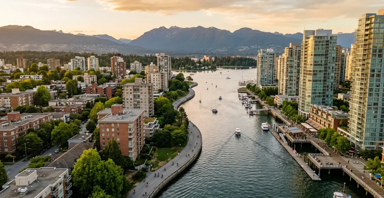
Can You Walk the Entire False Creek Seawall in One Afternoon?
Absolutely, and doing so is one of the best ways to understand the different personalities of Vancouver’s waterfront neighbourhoods. The False Creek seawall loop is the artery that connects the high-energy vibe of Yaletown with the relaxed, beach-focused culture of Kitsilano and the modern, family-friendly feel of Olympic Village. Walking it is not just exercise; it’s a narrative journey through the city’s recent evolution.
The main loop is approximately 11 kilometres and can be walked in 2-3 hours at a steady pace. However, to truly experience it, you should budget 4-5 hours. This allows you to absorb the distinct “vibe zones” you’ll pass through. You’ll start with the polished, high-energy Yaletown waterfront, with its marinas full of yachts and its bustling patio scene. As you cross over to the south side, you’ll enter the sleek, modern Olympic Village, and then the eclectic, artistic hub of Granville Island. Finally, the westernmost stretch on the Kitsilano side feels relaxed and beach-oriented, with stunning views back towards the downtown skyline.
A pro tip for this walk is to use the city’s charming mini-ferries. The Aquabus and False Creek Ferries act as shortcuts, allowing you to hop between 8 different locations around the creek. This is a perfect way to rest your feet, get a unique water-level view of the city, or simply break the walk into smaller, more manageable segments. For the best experience, walk the loop counter-clockwise in the afternoon; this keeps the sun on your face as you walk along the Kitsilano side, providing optimal light and warmth.
Yaletown’s Loading Docks: Why Are the Patios Raised Above Street Level?
The single most defining feature of Yaletown’s pedestrian experience is its iconic raised patios. As you walk down Mainland and Hamilton streets, you’ll notice that nearly every restaurant patio is elevated about a metre above the sidewalk. This isn’t a modern design trend; it is the most crucial piece of the neighbourhood’s architectural DNA. These platforms are the original loading docks from Yaletown’s past life as a gritty industrial hub of warehouses and rail yards in the early 20th century.
During the massive urban renewal that took place for the 1986 World’s Fair, history shows Yaletown was transformed from a heavy industrial area into one of the city’s most densely populated neighbourhoods. Developers made a brilliant choice: instead of demolishing the old brick warehouses, they repurposed them. They preserved the exterior loading platforms—which were built at the perfect height for loading goods onto train cars—and converted them into the elevated patios we see today. This act of adaptive reuse is solely responsible for Yaletown’s unique al fresco dining culture.
The Preserved Loading Docks: From Rail Platforms to Elevated Dining
Yaletown’s famous raised patios are a direct link to its industrial past. As detailed by Destination Vancouver’s neighbourhood guides, these platforms were the original loading docks for the area’s warehouses, designed for efficient transfer to rail cars. Preserved during the Expo ’86 redevelopment, they now provide the largest concentration of patio space in the city. This architectural choice creates a distinct “see-and-be-seen” atmosphere, physically separating diners from the street-level sidewalk. This fosters a sense of exclusivity and energy, a stark contrast to the more integrated, community-oriented street-level patios found on Denman or Davie Street in the West End.
This design has a profound effect on the walking vibe. The elevation creates a natural stage, turning dining into a form of public theatre. It contributes to a high-energy, “see-and-be-seen” atmosphere that feels both exclusive and exciting. The pedestrian texture is hard, polished, and commercial. It’s a stark contrast to the West End, where patios are at street level, blending seamlessly with the sidewalk and fostering a more casual, community-integrated feel. Choosing between Yaletown and the West End is choosing between these two fundamentally different social dynamics.
The West End Maze: Where to Park for the Beach on a Sunday?
If the roundabouts are the first clue to the West End’s pedestrian-first philosophy, the parking situation is the definitive proof. The honest, local answer to “Where do I park for the beach on a sunny Sunday?” is simple: don’t drive. The neighbourhood is a dense maze of resident-only permit zones, making street parking for visitors a frustrating, near-impossible task, especially on weekends. This is, once again, by design. It protects the quality of life for residents and strongly encourages walking, cycling, and public transit.
For visitors, trying to find a spot is a recipe for a ruined afternoon. Fortunately, the superior alternatives are abundant and far more enjoyable:
- Park Downtown & Bus In: Park in a large, accessible parkade downtown (like Pacific Centre) and take the #5 or #6 bus. These routes run frequently down Robson, Denman, and Davie streets, dropping you right at English Bay or Second Beach.
- SkyTrain & Scenic Walk: Take the SkyTrain to Burrard Station. From there, it’s a beautiful, scenic 15-minute walk down tree-lined streets into the heart of the West End. This is a perfect way to start absorbing the neighbourhood’s tranquil vibe.
- Use Car-Sharing: Services like Evo and Modo have agreements that allow their cars to be parked in designated spots within permit zones, making them a hyper-local solution.
If you absolutely must bring a car, your only realistic option is to arrive before 9 a.m. to snag a spot in a paid parkade, such as the one beneath Denman Place Mall, and be prepared to pay premium rates. All city-metered parking requires the PayByPhone app, so downloading and setting it up in advance is essential. This challenge, however, reinforces the core identity of the West End: it is a premier walking neighbourhood that rewards those who leave their car behind.
Key Takeaways
- Core Philosophy: The West End is designed for tranquil, human-scale living, prioritizing pedestrians and nature. Yaletown is built on a commerce-scale, repurposing its industrial past into a high-energy, polished urban experience.
- Pedestrian Vibe: Walking in the West End feels like a stroll through a peaceful, green residential park. Walking in Yaletown feels like being part of a dynamic, stylish, “see-and-be-seen” social scene.
- Key Feature: The West End’s identity is shaped by traffic-calming roundabouts and proximity to Stanley Park. Yaletown’s is defined by its iconic raised patios, which are repurposed historic loading docks.
How to Enjoy Gastown’s Charm While Avoiding Tourist Traps and Gritty Streets?
No discussion of Vancouver’s historic walkability is complete without mentioning Gastown. With its Victorian architecture, cobblestone streets, and famous Steam Clock, it offers a charm that is distinct from both the West End and Yaletown. However, enjoying its authentic character requires a smart strategy to navigate both the tourist-heavy spots and the grittier streets that border the Downtown Eastside. The pedestrian texture here is historic and raw, a sharp contrast to Yaletown’s polished version of heritage.
The primary tourist trap is spending too much time at the Steam Clock on the corner of Cambie and Water Street. While a fun photo op, the real soul of Gastown lies elsewhere. The local gem to seek out is the network of hidden courtyards and alleyways. Venture into Gaoler’s Mews and Blood Alley to find some of the city’s most unique independent boutiques, restaurants, and a palpable sense of history that the main drag lacks. A safe and rewarding route is to start at Waterfront Station, walk east down the main tourist thoroughfare of Water Street, and then shift your focus to the parallel Cordova Street, which offers a more authentic local character with its design shops and galleries.
It’s crucial to be mindful of your surroundings, particularly east of Abbott Street and along Hastings Street, which runs parallel to the south. Stick to the well-lit, commercial areas of Water and Cordova streets, especially in the evening. For a truly high-value cultural experience, bypass the generic souvenir shops and explore Gastown’s thriving First Nations art scene at reputable galleries like the Inuit Gallery of Vancouver. This offers a much deeper connection to the region’s true heritage.
Your Action Plan: Smart Gastown Exploration
- Identify Targets: Pinpoint key locations beyond the Steam Clock. Prioritize courtyards like Gaoler’s Mews and Blood Alley for authentic history and unique shops.
- Map Your Route: Plan a path starting at Waterfront Station, focusing on Water Street for the classic view, then transitioning to Cordova Street for independent galleries and boutiques.
- Check for Coherence: Acknowledge the area’s boundaries. Be mindful that east of Abbott Street and along Hastings Street requires increased situational awareness. Plan to stay within the main commercial zones in the evening.
- Assess Value: Differentiate between tourist traps and authentic culture. Opt for visiting a renowned First Nations art gallery over a generic souvenir store for a more memorable experience.
- Plan Integration: For a structured and safe exploration, consider booking a guided tour with a local company. This integrates expert knowledge with a secure way to see the neighbourhood’s hidden corners.
Now that you understand the distinct architectural DNA and pedestrian textures of these core neighbourhoods, you are equipped to make a choice that goes beyond a simple hotel booking. You can choose the Vancouver experience that truly resonates with your personal style. The next step is to walk these streets yourself, with this new perspective, and feel the difference firsthand.